Geomorphic Change Detection (GCD)
Geomorphic Change Detection is a technique by which changes from the geomorphic processes of erosion and deposition are inferred from repeat topographic surveys.
 Due to the quantitative and spatially explicit results it yields, geomorphic change detection is rapidly becoming a more common tool in the monitoring of rivers and in particular restoration monitoring. The biggest challenge in employing such techniques is quantitatively distinguishing changes due to geomorphic processes from those changes due to noise and uncertainty inherent in the digital elevation models.
The GCD is a suite of GIS tools that work within the ESRI ArcGIS Desktop software.
GCD Features:
- Interactively perform DEM (Digital Elevation Model) of Difference analyses, including simple, propagated error, and probability thresholding.
- Perform Budget Segregation analyses on a variety of raster surfaces.
- Calculate error surfaces from DEM data, including: fuzzy Inferencing System (FIS), single-uniform errors, multi-uniform errors, and combinations of FIS and uniform errors.
- Create bounding polygons (concave hulls) on input point data.
- Convert point clouds to DEM raster surfaces.
- Make raster grids concurrent.
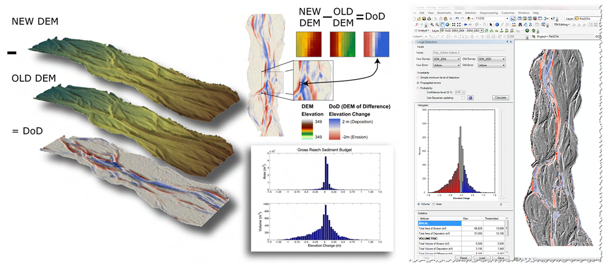
The GCD software was developed primarily for morphological sediment budgeting in rivers. The volumetric change in storage is calculated from the difference in surface elevations from digital elevation models (DEMs) derived from repeat topographic surveys. As each DEM has an uncertain surface representation (which might vary in space and time), our ability to detect changes between surveys is highly dependent on surface representation uncertainties inherent in the individual DEMs.
The fundamental problem is separating out the changes between the surveys that are due to geomorphic change as opposed to noise in the survey data. GCD provides a suite of tools for quantifying those uncertainties independently in each DEM and propagating them through to the DEM of difference. The program also provides ways for segregating the best estimates of change spatially using different types of masks. The overall suite of tools is more generically applicable to many different spatial change detection problems.
Schematic of the concept underlying the GCD, along with a screenshot of its user interface.
Keywords & Themes: Water resources / Riparian and geomorphic change / Open crowd sourced data / Geospatial tools / Time-series roll-up
- Dr. Joseph Wheaton also maintains a website dedicated to his Geomorphic Change Detection research.
- The US Forest Service, Rocky Mountain Research Station also maintains a website dedicated to their River Bathymetry Toolkit research project.
Key Contacts
Contact us if you have any questions or would like to discuss the current or future GCD feature set.