Natural Assets for Coastal Protection

Project Details
Location: |
Gibsons, BC; 49.39711, -123.51335; Pointe-du-Chêne, NB, 46.23810, -64.51740 | |
Client: |
David Suzuki Foundation | |
Duration: |
2018 – 2021 | |
Team Member(s): |
Cedar Morton, Erica Olson, Matt Bayly, Hugh Stimson | |
Practice Area(s): |
Nature Based Solutions | |
Services Employed: |
Ecological modelling, GIS analysis, Natural asset inventory, Natural asset planning and decision support, Economic assessment, Facilitation & engagement, Science |
The Problem We Aimed to Solve
Municipalities across Canada are confronted by aging infrastructure for key services like flood mitigation. This infrastructure is costly to replace, but natural assets can sometimes be used to provide the same levels of service at less cost while simultaneously contributing a range of co-benefits, like recreation opportunities, that engineered assets do not deliver. The David Suzuki Foundation in collaboration with the Natural Assets Initiative wanted to understand how natural assets could be used for coastal protection against flooding and erosion from storms. Additionally, they wanted to develop a tool that could be used by municipal staff to provide a first-pass assessment of whether coastal natural assets are a good idea.
How We Helped
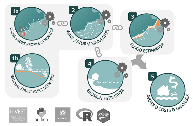
ESSA developed a community-scale Coastal Natural Assets Valuation model (“Coastal Toolbox”) that assesses different natural infrastructure alternatives and evaluates the economic benefits resulting from wave attenuation (i.e., damage reduction from floods and erosion).
We worked with the Town of Gibsons (British Columbia, Canada) and the Southeast Regional Service Commission (New Brunswick, Canada) to develop two pilot studies using an ESSA-adapted version of the InVEST Coastal Protection Module (not part of InVEST’s main suite of tools). This was a multi-year project that involved natural asset inventory, conceptual modelling, indicator development in collaboration with the two coastal communities, and complex programming to develop batch-processed transects along coastlines that can then be interpolated to provide a semi-2D spatial representation of flood and erosion extents.
Our Project’s Impacts
This award winning project (Canada Clean50 Top Projects Award) produced a coastal natural asset inventory and a model for third party use using an ESRI user interface (i.e., an ArcToolbox) coupled with an R Shiny “sandbox” mode for ease of parameter testing along single transects without running the full model. The model is packaged for use by multiple Canadian communities, along with a user guide, to support a first-pass assessment of natural asset options.