Factoring Climate Change into Environmental Impact Assessment and Assessing Disaster Risk in El Salvador

Working with the El Salvador government to integrate low carbon and climate resilience into the environmental impact assessment process and modelling natural disaster risks to critical infrastructure in order to strengthen the country’s disaster preparedness, response and climate resilience.

Location: |
El Salvador; 13.540164, -89.111572 | |
Client: |
El Salvador Ministry of Environment and Natural Resources (MARN) | |
Duration: |
2015 – 2017 | |
Team Member(s): |
Jimena Eyzaguirre, Tim Webb, Natascia Tamburello | |
Practice Area(s): |
Climate Change Adaptation, EA/CEA | |
Services Employed: |
GIS Analysis & Information Systems, Ecological Modelling, Capacity Development & Training, Science Communication & Knowledge Synthesis |
Together with our local partners WESA-BluMetric Environmental Inc., we led two projects for the Ministry of Environment and Natural Resources (MARN) in El Salvador. The first was to integrate climate resilient low-carbon considerations into the environmental impact assessment process and the second was an infrastructure risk assessment that examined the vulnerability of critical infrastructure to natural hazards.
Already vulnerable to natural hazards, El Salvador is especially sensitive to climate change impacts.
El Salvador is the smallest and most densely populated country in Central America. Due to a combination of topography, location and weather systems, the country is vulnerable to some of the most damaging types of natural hazards such as floods, landslides and earthquakes. It is also highly prone to the impacts of climate change and has seen a steady increase in extreme events such as storms, floods and droughts during the last 30 years. For example, 39 hurricanes hit Central America between 2000-2009 compared to 15 in the 1980s. The country’s Pacific coastline is already experiencing rising sea levels and between 10-28% of the country’s coastal zone is expected to be lost by 2100.
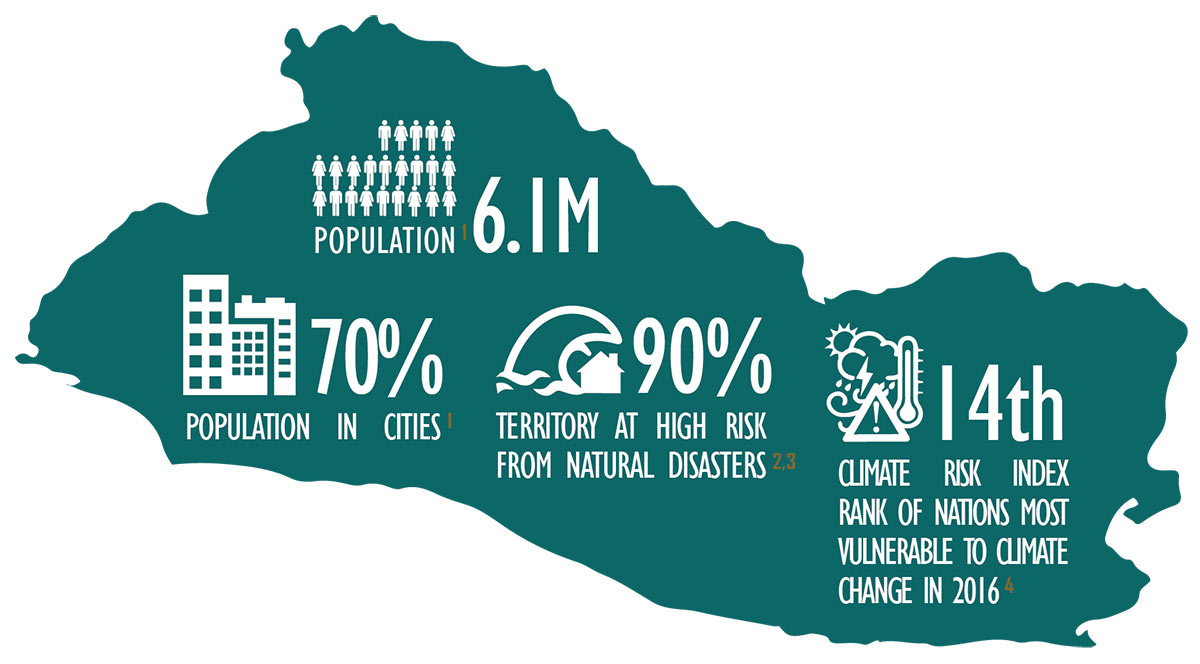 Infographic overview of the country of EL Salvador and it’s particular sensitivity to climate change hazards.
As climate change progresses, the country is expected to see even further impacts to its agriculture, water resources, ecosystems, infrastructure, energy production and human health, as average temperatures increase further, precipitation decreases, droughts lengthen, sea levels rise, and more frequent and more extreme weather strikes.
El Salvador has already experienced a bitter taste of what’s to come and is eager to adapt and mitigate the high cost of these weather and natural disaster events.
Following the devastating impacts of Hurricane Mitch in 1998 and two earthquakes in 2001, disaster risk management rose to top of mind both for public and government in the form of a national policy agenda. More recently, tropical storms and intense rainfall events have further illustrated the country’s vulnerability to extreme weather. As a result, the country is committed to both climate action and disaster preparedness and response in order to help weather both the figurative and literal storms to come.
Much of the policy action on this front falls under the auspices of MARN, which leads the national effort to address climate risk and also houses the national Environmental Observatory.
Better understanding disaster risk and climate compatible development.
El Salvador is highly vulnerable to natural hazards. It’s located in one of the most earthquake-prone regions of the world and also lies in the path of both Atlantic and Pacific tropical storms. The country is dominated by drought and heavy precipitation, which in turn leads to flooding and landslides. Then there is its 307-km long Pacific coastline that is already experiencing rising sea levels. The country of 6.2 million people may be small but it suffers more than its fair share of natural hazards and disasters.
One of the first steps in minimizing the effects of these disasters and in protecting lives and economic assets from loss and damage is to assess disaster risks to critical infrastructure.
Not only does this help to better understand what the hazards are but it also illuminates what the country’s vulnerabilities (be they physical, social, economic or environmental) to it are. Thus, the Government of El Salvador requested a national multi-hazard study to identify the risks presented by a range of natural hazards on infrastructure of strategic importance in El Salvador.
Another avenue that El Salvador wanted to pursue in its fight against climate change impacts was to incorporate climate change considerations into its environmental impact assessment (EIA) process. EIA is a natural vehicle for so-called “climate compatible development” through which project proposals can support reductions in greenhouse gases and help to neutralize the adverse impacts of climate change.
Assessing disaster risks to infrastructure and looking at EIA through a climate change lens
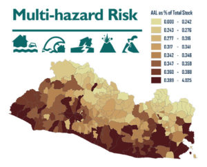
ESSA assessed disaster risks to infrastructure through a national multi-hazard study on existing infrastructure of strategic, economic and social importance to the country. The study modelled almost 100 different hazard scenarios (from landslides, flooding, tsunamis, and earthquakes to volcanic activity) and the physical vulnerability of seven infrastructure categories including: major roads, highway bridges, transmission towers, electrical sub-stations, water and sewer infrastructure, schools and healthcare facilities.
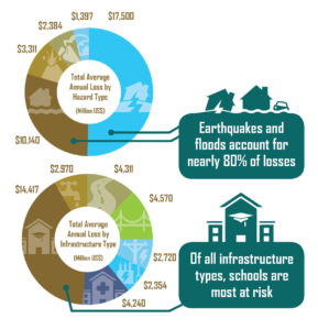
Our study concluded that the total average annual loss (a common risk metric that represents the expected loss per year averaged over many years) for infrastructure studied came to $35.5 million. Earthquakes and floods were by far the most destructive, accounting for 80% of those financial losses. The study also mapped natural hazards across the country to produce a hazard atlas that will prove critical to land use planning and development decisions going forward.
 The natural hazard risk analysis we provided the Salvadorian government has armed them with the information they need to help prioritize infrastructure reinforcements and retrofits and make decisions on local infrastructure planning.
An example of a hazard risk map produced for El Salvador as part of this project, showing in this case the total average annual loss (AAL) for Healthcare Facilities to natural hazards, by municipality and expressed as a percentage of total stock.
A subsequent series of case studies provided more comprehensive metrics for natural hazard risks beyond simple replacement costs of infrastructure, analyzing the direct, indirect, induced and macroeconomic costs to El Salvador of infrastructure loss and damage.
An overview of average annual losses (AAL) in El Salvador for seven infrastructure categories studied through modelling of numerous hazard scenarios, which add up to roughly $35.5 million per year.
A second component to our work in El Salvador involved strengthening institutional capacity with respect to incorporating climate change into EIAs. Before the project started, EIA reviewers at MARN noted the need to understand how the impacts of climate change might affect a project or how the combined effects of the project and climate change might affect valued ecosystem components, or whether the project might be a high emitter of greenhouse gases. However, MARN lacked clear requirements and tools to ask proponents to account for climate change in a systematic way.
We looked at the EIA process to identify entry points for including information on climate change impacts, adaptation, greenhouse gas emissions and mitigation, and based on those entry points develop tools to help integrate information about climate change into steps in the process.
 Further to that we also helped to develop non-expert screening and monitoring tools for MARN. These included: climate change screening criteria and indicators for initial environmental review; an operational guidance document on the integration of climate change considerations in project-level EA; and a toolkit for review and follow up by MARN. We also delivered a capacity training program that helped to ensure the MARN staff were well versed in how to use their three climate-integrated tools. By the end of the two-year project, we delivered 124 hours of training and facilitation. We brought 47 of MARN’s staff up to speed on the basic causes, effects and actions of climate change, we introduced 43 individuals from public-sector project proponents to MARN’s initiative to integrate climate change in EIA, and helped lead 16 technical specialists within MARN and other government agencies to apply our 150-page EIA guidance note to three existing EIAs for projects that had already received permits.
“The idea is that you have these project concepts going through the EA process and depending on the types of project they are more or less fixed in their design,” explains Jimena Eyzaguirre, international team director at ESSA and our climate change adaptation lead explains. “But if there is still some wiggle room to change their design for example, a major highway segment, to use less impermeable surfaces that help drainage during high precipitation events then proponents have the opportunity to make those slight adjustments. In this way, it’s possible to use the EIA process to help the country adapt to climate change and or reduce GHG emissions.”
- CDKN Project Profile
- MARN Project Infographic